The increasing demand for full 3D above- and below-ground surveys, along with the recent innovations, such as the MS60 scanning total station, the GS18 T tilt rover, UAVs and high-speed laser scanners, makes it possible for solo surveyors to compete on a global level with a diversified client base. Jason Stivers, owner of Stivers Land Surveying, shares how strategic technology investments keep his own company productive, efficient, successful and excited about the future.
BK: Many surveyors, at some point in their career, have dreams of going solo and running their own firm. Nearly two years ago, Jason Stivers decided to take that leap. As a licensed land surveyor in Tennessee, with more than 20 years of experience, Jason had a solid understanding of what it would take to operate his own business. But Jason didn’t just buy a total station, hang out a shingle, and wait for the phone to ring. We’re going to talk about that.
Welcome to HxGN Radio. My name is Brian, and joining me today is Jason Stivers, owner of Stivers Land Surveying, and he’ll be telling us more about how strategic technology investments are helping him to run a successful company and redefine land surveying. Jason, welcome. Thanks for joining us.
JS: Good to be here.
BK: All right, well, why don’t you tell us a little bit about you, your company, and how your journey in surveying led you to establish your own company.
JS: Well, I’ve been surveying for about 25 years. I started in Illinois and migrated to Tennessee. Worked for several companies, doing a lot of wide range types of surveying for engineering companies and different things, mining companies. At that point, I kind of decided that they weren’t necessarily using technology the way it should be used to produce a higher end product, a better product. So that’s where, when I had the opportunity to go on my own, I decided, hey, I want to use the high-end stuff. I want to use the equipment that’s going to produce a better, higher-end product than my competitor. And I think that’s where I’m moving towards, to get more in the niche markets and things like that, to be more successful in what I’m doing. I’m not looking at the same kind of just boundary surveys, and especially as a small company, you’re kind of overlooked because you’re a small company. But with the equipment that I have, I can compete with bigger companies and produce a nice product.
BK: Excellent. That’s the way to do it. All right. Well, explain the need for a new kind of surveying that you’ve identified.
JS: Well, like I said, I work in a lot of niche markets, underground mines, things like that. And so, I think that’s where the technology comes in because I can’t do what I can do in the same time that a bigger company can, so I have to use technology to speed what I’m doing up. And that’s where the 3D scanners, the MS60, the GS18, like that come in handy to help me do my job more efficiently and produce a higher-end product.
BK: Okay. Yeah, that makes a lot of sense. I mean, of course you’re competing with bigger companies that have the budgets and other things, so getting into those niche markets really is what’s going to allow—and you’re doing well.
JS: Yes. That’s the thing. Smaller companies tend to stick to lot surveys and simpler surveys. I don’t want to do that. I want to do the neat projects, the fun projects, the projects that you kind of look at and go, wow, should I do that? That’s where I’m heading towards. That’s what I want to do.
BK: Good, good. Well, congratulations on what you’re doing and where you’re going. I like that. All right. You’ve already mentioned a few of the Leica Geosystems solutions, but go ahead and talk a little bit more about what you’re using, how it’s helping you to make your work a little more productive as well.
JS: One of the main things I use is an MS60, which is the scanner, total-station robot. I do a lot of mine work where we have to set the control and do 3D scanning. So, it’s perfect for that, just in the fact that I can go underground, set the control, hit the scan button, and let it do its job. It’s quick, it’s easy, it’s fast, efficient, and also, it’s very well-suited for mines as far as the water, the dust, the dirt. Those kinds of atmospheric conditions are not very well in a mine, so having that makes it a whole lot easier. And it gives me a peace of mind, I guess. It’s not going to go out on me. Then we use the GS18, and that’s probably my favourite piece that I have right now because it’s just the way you can use it. I’m doing topos in the woods that are completely wooded, that typically I would never be able to do by myself. It’s really, really doing an amazing job in actually getting the shots that I need in the thicker woods, in the areas that I typically would have to take a total station in and do it, and it would take me three to four times as long. And then I pair those two up, and since I work by myself, I can set my MS60 up to scan, and then I can take off with my 18 to go do what I need to do with it, and I’m running, basically, a two-man crew by myself.
BK: Then you come back, and you grab everything and—
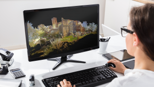
JS: Then I dump it into my Cyclone and Reshaper and let it do its thing.
BK: It’s awesome. That’s fantastic. I like that. I like being able to say, you know, you can go out and do your two-man crew kind of thing and grab what you need. And that’s efficient.
JS: Yes, it is. And that’s what I’m looking for, and that’s what helps. You know, we’ve gotten into the RTC360, so that’s something new. And then the DS2000—which, we’ve got a project, we’re getting ready to start with that—which is an underground utility location. We’re doing some hospitals where there’s a lot of utilities. And the previous client, they hit a power line that shut the whole hospital down. That’s where they’re, apparently, we’re going to use the DS to go in and locate the depth of the utilities, so that’s not going to happen. So that’s the kind of the markets I’m trying to get into.
BK: Sure. Okay. So, obviously, you shared quite a few of the benefits and everything like that. If you didn’t have these solutions, would you be able to even do what you’re doing or even go down that path you’re wanting to go at all?
JS: No.
BK: So, you’d have to kind of resort to the things you didn’t—the more boring things, as you’ve said earlier.
JS: Right. Right. And that’s where, when I first started. I didn’t have this, and that’s where I quickly, within a few months, changed. Because I was like, I don’t want to go down this path, and if I don’t move now, it’s not going to happen. So, there were a few opportunities that I jumped on fairly quickly, and I think the equipment helped me go down that path that I wanted to go down, not go the other path.
BK: What was a learning curve for these Leica solutions?
JS: Still a learning curve. They’re always updating, so everything’s changing, and I’m getting new software, better software, that’s better suited for what I’m doing. So, it’s always a learning curve.
BK: But it’s always improving.
JS: Oh, yes. It’s definitely always improving. The learning curve for me is just making it more efficient, making it better for what I’m doing and what I need to do with it. And Leica, their tech support’s great about helping you figure those things out. So, they’re really great about that.
BK: So initial learning curve, though, to get up and running, at least to get out there?
JS: Eight hours.
BK: Oh, wow. That’s simple.
JS: It wasn’t hard. It’s simple. That’s it. It’s simple to start out with. It’s when you get into the complex stuff. The more intricate stuff is where you have to really start tweaking, so the software was a little bit longer of a learning curve. But as far as running the instruments, it was eight hours.
BK: That’s good. I mean, you know, honestly, that’s pretty short in comparison to a lot of other solutions that are out there. You know, you can look into stuff that could take days, weeks, even, trying to really understand it enough to be able to utilize it. So that’s great. All right. Well, which onboard software applications do you normally use for daily work?
JS: Oh, Captivate. So, it’s all in everything, so that’s what we use. It’s just a quick Captivate.
BK: Excellent. A little bit more about that and how it’s working for you.
JS: The Captivate, it’s more designed, I guess, for doing the underground work that I do and things like that. I think that really helps me there with the scanning in the MS60 and the GS18, and being able to know what you’re getting when you’re getting it. Some of the applications really show you what you actually have at that time. I don’t have to wait to go back to the office to process it. I can see what I have and tell my clients, “Hey, this is what we’ve got right now.” So, I like that part of the Captivate.
BK: Good. All right. Now you’re using the MS60. You’ve mentioned that. What are some project examples where you’re actually utilizing that?
JS: I am doing about two different mines right now. One of them is a limestone mine, where we’re in there every week monitoring, and we do it for its volumes. And then we do the same thing at a zinc mine, where we’re there probably once a month. But we’re doing 50, 60, 70 scans a day when we go in there just for their volumes. And we do fault monitoring, which the MS60’s great for that — so we’re monitoring faults. And then I do some scanning, just normal scanning projects, actually, for architects, things like that.
BK: Is that more the daily work kind of thing at that point, or—
JS: Yes. We do a lot of stuff for architects and engineers, things like that, so we use MS60 for that, and then hard-to-reach places, things like that. And plus, like I said, I just use it just to give me an extra hand to go.
BK: That’s great. Well, I mean, you’ve shared a lot on this. You’ve already talked about some of the things, but any other information on some of the Leica Geosystems technology that you’re using? I mean, you’re using a lot, obviously. You’ve mentioned it’s helping you to save time, it’s creating more efficiency, it’s got a good learning curve. It’s obviously allowing you to do stuff that you’ve been wanting to do that the bigger companies can do, but what else? Is there anything else that this technology is doing to help you save time, for example, providing better quality for your customers?
JS: The thing I’m learning is a lot of the clients aren’t used to getting 3D scans, things like that. This is where I’m going in and going, “Hey, look at this.” I’ll scan it just to give them an example. And so, it’s picking me up more business doing it that way just because they’re not used to seeing it done, what you can do with it. They don’t know what applications they can use, and so I’m trying to teach them, “Hey, this is what we can get.” And they’re really liking that part of it. We’re kind of pushing the market for the engineers that aren’t used to having that kind of product. And then also some other niche markets I’m trying to get into with it is, is other applications we can use it for. And then, plus, just the time that I save, time’s money, so if I can cut my job time in half that’s more money that I’m going to make. So, that’s the plus for me. Plus, it gives me more time to take on more projects. Where I would have to turn them down, I can actually take them on now and handle a higher workload for what, typically, I wouldn’t have.
BK: Well, you’re doing the quadruple-, quintuple-win thing going here. So, you’re doing what you love, you’re cutting your time in half, you’re making more profit, and, of course, your customers are happy, and they’re impressed by the deliverables, too. So great. Great. I love it. All right, so, a lot of solutions out there, a lot of surveying solutions. Why did you decide to trust and invest in Leica?
JS: I’ve run the other ones, and just the issues that I had and the testing out the Leica equipment, it was just so far above what they were doing and what I could do with it. The GS18, for example, the no tilt on it is amazing. For construction stake and layout, and just for surveying in general, it’s faster, it’s safer. If want to get a shot out in the road, I don’t have to stand in the road. I can lean the rod over and actually get a shot. I don’t have to worry about standing in the road, in the way of traffic. And working by myself, it’s something I think about.
And just the speed of it. It’s just so much faster to do it, you know? I mean when you do topography, you have to sit there and put the plumbing rod up and move on. You just set it down, hit the button, set it down, hit the button, and you can really, really, really go fast. That’s one of the reasons why. And the quality. I know it’s a very high quality. Like I said, the conditions I work in aren’t the best sometimes, so having that peace of mind, knowing that they’re fully dustproof, waterproof, things like that, really, really help me out.
BK: Oh yeah, for sure. I mean, that’s something that has to be a huge consideration, like you said, going into uncertain environments because certain equipment’s not going to stand up so well. And guess what? You’re replacing them, you’re having problems with them, you’re fixing them. At least these are almost environment-proof in a way.
JS: Yeah, they are. It’s peace of mind.
BK: Yeah. Anything else you want to share on these? Sounds like you’re doing really well with this.
JS: I’m trying to think. That’s probably about it, I guess. I mean, just the fact that I think it’s opening up new markets for me, and I think that’s what I’m excited about. I’m not doing the same thing all the time, and we’ve got new things coming up that we’re going to start doing. It’s even going to be more exciting, so it should be fun. I’m enjoying the surveying again, so it’s a fun thing. And I’m not doing the boring, old lot surveys and things like that.
BK: That’s great. I love to hear when things empower you. So, good job. And, well, thank you very much, and congratulations on all this. And thank you for sharing this information. Jason, thanks for your time today. Appreciate it.
JS: No problem. Thank you.
BK: All right. For more information on today’s topic, please visit stiverslandsurveying.com and leica-geosystems.com. To learn more and listen to additional episodes, head over to hxgnspotlight.com. And thank you for joining us here on HxGN Radio.


