


Although still in its nascent stage, the metaverse has been a trending topic long before Meta cemented the idea in popular culture and brought the conversation to a larger audience. Gartner predicts that 25% of people will spend at least one hour in the metaverse every day by 2026, while a recent McKinsey report found that the metaverse could generate up to €5 trillion in impact by 2030 alone. With such high expectations for the role the metaverse will play in the future, organisations are only just beginning to explore the potential benefits that this digital environment has to offer.
While the term “metaverse” is often used to demonstrate new leaps forward in immersive entertainment — such as social experiences in virtual reality or video games set in fantastical spaces — Hexagon’s vision is bigger. The metaverse isn’t just for entertainment and it’s not just about individuals; it’s about interconnected data across parallel real and digital worlds — worlds ultimately fused together and treated as one. Data, whether it’s representing hyper-realistic visualisations of spaces or objects, or providing insights previously inconceivable without machine learning and artificial intelligence, is the key to unlocking the true power of the metaverse.
We see value in Smart Digital RealitiesTM, 3D worlds that serve as 1:1 replications of reality — from physical objects or places to entire environments. Rooted in reality, they provide complete line of sight to ever-changing situations in the real-world. To make these digital versions truly intelligent, we infuse them with real-time data inputs so as the world changes, it’s reflected in the digital counterpart. Or vice versa, so that what we learn or simulate can be actioned in the physical world, in real-time (or near real-time). And through the implementation of autonomous technologies, these Smart Digital Realities become autonomously intelligent, enabling action and decision-making independent of human interaction.
The Smart Digital Reality will enable businesses to connect real people, places and things to the metaverse. With real-world accuracy, fidelity and ground truth they can learn in real time what actions need to be taken in the physical world or simulate scenarios virtually to understand expected outcomes. But, to set the best foundation for these Smart Digital Realities, businesses must start by accurately digitising the real world.
Building the foundation
Various reality capture technologies — such as LiDAR scanning and high-resolution imaging — allow us to fuse high-quality image data gathered from multiple sources to create an exact, dimensionally accurate representation of the physical world.
3D laser scanning was previously a tool reserved for an exclusive few with the technical know-how to apply it properly. Today, however, laser scanning has become so widely available and democratised that it can be easily implemented and used by both professional and lay users alike. Leica Geosystems’ BLK portfolio provides several options when it comes to 3D laser scanning, from autonomous reality capture robots and flying laser scanners to terrestrial scanning systems and handheld imaging laser scanners.
The newest member of the BLK series, the all-new Leica BLK360, is a portable imaging laser scanner that is even smaller and faster than the previously record-breaking and award-winning BLK360 G1 that was released in 2016. Using LiDAR technology to measure and map the spatial dimensions and shapes of sites and objects, this data is used to create a point cloud, which is the foundation for a 3D digital model.
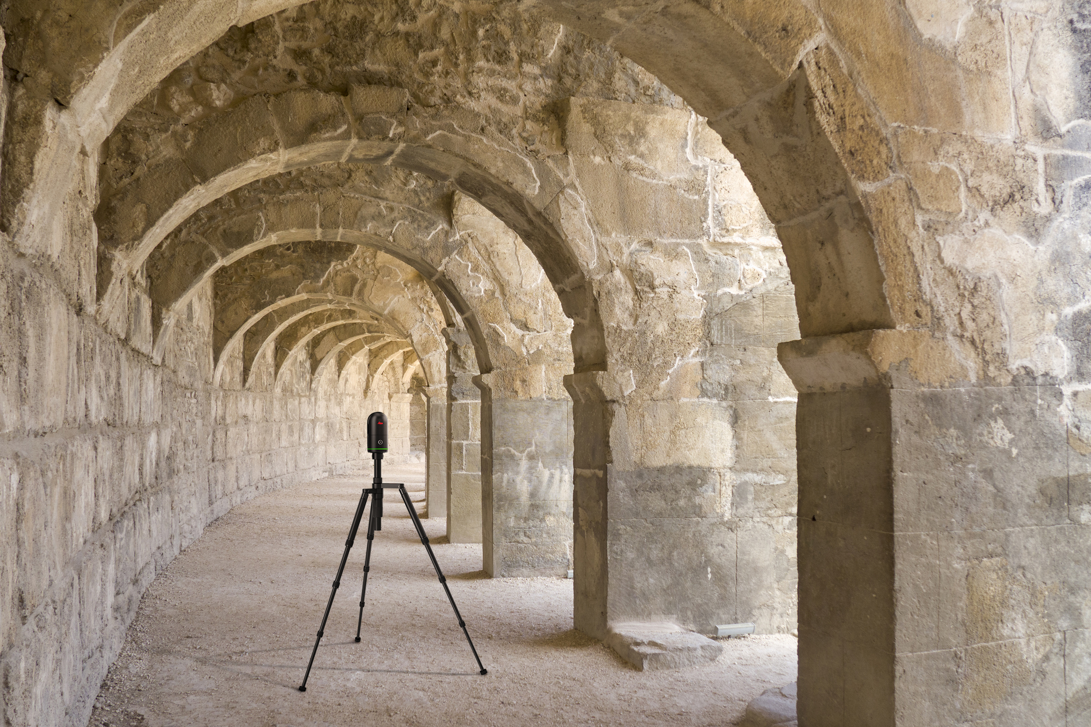
A new feature in the all-new BLK360 is the inclusion of Leica Geosystems’ Visual Inertial System (VIS), previously available with the Leica RTC360 3D laser scanner. VIS is important because it allows the scanner to track its movements easily and accurately within an environment to combine individual scans automatically. This means you can move the BLK360 from point A to point B and easily connect the point clouds in post-processing — minimising wasted time and inefficiency.
In addition to LiDAR, the BLK360 uses a four-camera system to capture HDR photospheres, necessary for a completely realistic look and feel within the digital space. All this information comes together in an easy-to-use mobile app that allows users to ensure every detail is captured before leaving the site.
Next, a mobile application automatically pre-registers the data, aligns the visuals, cleans up the images and provides multiple visualisation and export options. From there, you can export the data to your application of choice to build your own brand-new realities from your point clouds.
Moving towards a Smart Digital Reality
At this point, you have a digital twin — a one-to-one 3D replication of reality in a digital space. This snapshot in time is where many people and businesses will stop; however, doing so means working with information that can quickly become obsolete or out of date. This is a critical difference between a digital twin and a Smart Digital Reality, which leverages real-time data to remain useful.
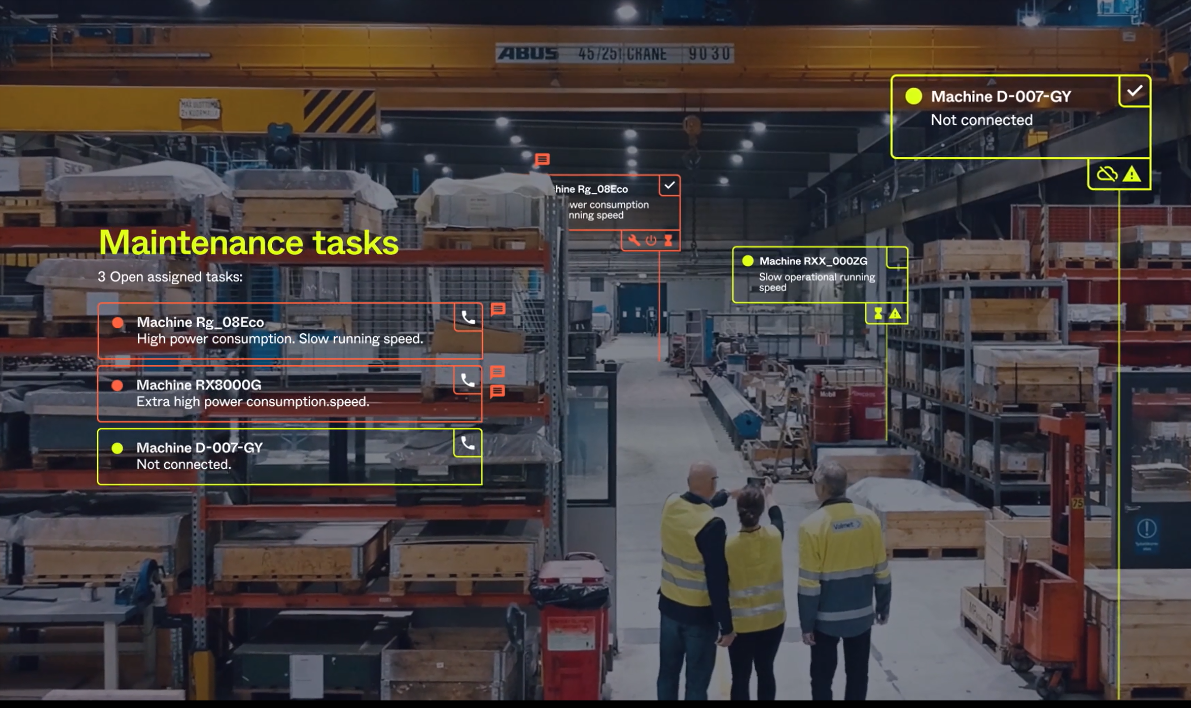
Many inputs can be plugged into the Smart Digital Reality. For example, autonomous sensors, such as the BLK ARC and BLK2FLY, continuously capture environments and automatically upload the data for use without human intervention, ensuring changes in the real world are reflected in the digital equivalent.
Data from airborne reality capture can provide additional context in the digital environment. For example, Hexagon’s HxGN Content Program offers geospatial content and delivers professional-grade airborne images captured with Leica Geosystems’ airborne sensors.
Next, AI and machine learning can autonomously assign meaning to various objects within the 3D model, ensuring a functional representation. For example, the ability to recognise the difference between a high-rise glass building — which would have reflections — and a brick house means each must be displayed accordingly. It’s this intelligence that ultimately brings the conditions of the real world to your digital representation.
Now, you can visualise what doesn’t yet exist. For example, an architectural firm could render a building design based on a physical location, simulating different weather scenarios to evaluate the impact of different seasons or airflow. This enables a digital sandbox within real-time data where you can ask what-if questions and see how new designs fit without making costly mistakes or creating excess waste in the real world.
You can take this concept of the metaverse one step further through spatial anchoring, which essentially allows you to bring digital information and experiences into the real world through augmented reality (AR). Imagine that a maintenance team is alerted that a specific piece of equipment in a plant requires action. If the assets in the plant are digitally and spatially anchored to physical locations, employees can use a tablet, smartphone or AR glasses to view critical information about the asset while on location. This augmented view could also be used to help navigate to the correct machine in order to perform the recommended corrective tasks.
Preparing for the metaverse now
With so many impressive applications, the metaverse sounds like a futuristic ambition; however, it is here now.
Businesses can create intelligent, accurate, 3D spaces rooted in reality within the metaverse by incorporating reality capture into their workflows today. Hexagon’s reality capture solutions enable Smart Digital Realties so organisations can put data to work in new ways, boosting efficiency, improving sustainability and workplace safety and improving team communication and collaboration.
You can learn more about where the metaverse meets business in my recent keynote presentation for HxGN LIVE Global 2022. I look forward to sharing even more exciting developments in Hexagon’s contributions to Smart Digital Reality soon.


