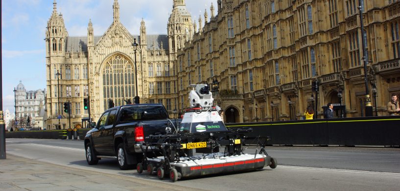
I remember being very happily surprised at the Geo Business 2016 conference in London when on the street outside the conference I spotted the towable combined above ground/below ground scanner, which combined a Leica Pegasus:Two mobile mapping platform with the IDS GeoRadar Stream EM ground penetrating radar (GPR) array. These are designed to make it possible to survey once, covering above and below ground simultaneously. This represented the first significant investment by a major survey equipment vendor in subsurface utility detection technology.
In the U.S., an underground utility is hit every minute (360,000 incidents in 2016). Underground utility conflicts and relocations are the No. 1 cause for project delays during road construction. The estimated total cost to the U.S. economy is $50 billion annually and this is a conservative estimate. A Pennsylvania State University study commissioned by the Pennsylvania Department of Transportation (DoT) found a return on investment of $21 saved for every $1 spent on elevating the quality level of subsurface utility information.
Currently, the exchange of underground utility information between infrastructure organisations within the same jurisdiction or in adjacent jurisdictions has been greatly hampered by incompatible and incomplete data. The Open Geospatial Consortium (OGC) intends to make a significant contribution towards facilitating improved information management, sharing and collaboration, which should make infrastructure planning, operations and maintenance, and emergency response less costly and time consuming, and more effective. The OGC has initiated a three-phase project to develop interoperability standards for underground infrastructure.
Exploring GPR at HxGN LIVE
There was an excellent overview of GPR at HxGN LIVE this year by Dan Bigman of LearnGPR. GPR devices (for example, the Leica DS2000) not only can detect nonmetallic objects but also provide 3D location – reporting depth as well as X and Y locations – which makes GPR a superior mapping technology for subsurface utility detection. But GPR does have drawbacks. It requires a trained operator to interpret the scans. Secondly, current devices are intended to operate at a walking pace making GPR inefficient compared to mobile laser scanning, for example.
Two years ago, Hexagon acquired IDS’ GeoRadar division. The first significant technology announced by Hexagon after the acquisition was the towable Pegasus:Stream array. Designed to be towed by a vehicle at speeds up to 15 km/hr (though 5-10 km/hr provide the most accuracy), it was designed to provide simultaneous above and below ground 3D scanning. It includes a mobile laser scanner with laser scanners, optical cameras and GNSS receivers for above ground features and a Stream EM GPR array for below ground objects. This was a major technology announcement at the 2016 HxGN LIVE event where I had the opportunity to chat with Stuart Woods, Leica Geosystems Vice President of Mobile Mapping, who made it clear that Leica Geosystems saw a major opportunity in underground utility detection and that the GeoRadar investment would be followed by more significant investments in underground mapping technology.
Since then, I have had the opportunity to chat with Katherine Broder, President Construction Tools Division at Leica Geosystems in Heerbrugg about Leica Geosystem’s vision for the future advancement of underground mapping hardware and software. Broder said that Leica Geosystems intends to democratise this technology to the broader professional market by making the technology more accessible. The biggest constraint limiting GPR penetration is the difficulty of interpreting GPR scans. Leica Geosystems developed DX Office Vision Utility post-processing software to enable users with minimal training to extract pipes and other infrastructure from GPR data into a CAD drawing with minimal training.
Hexagon’s IDS GeoRadar division introduced the Stream C, a compact GPR array solution for real-time 3D mapping of underground utilities that is equipped with software for automatically mapping underground infrastructure. Using a massive antenna array together with software for tracing signals across multiple scans the system automatically detects and locates the position of pipes in real time and displays them on a screen. The system can be towed by a small vehicle at an acquisition speed up to 6 km/h.
Geoff Zeiss
Principal
Between The Poles
@gzeiss
![]() Geoff has been tracking the contribution of geospatial technology to the digitization of construction, operation and maintenance of energy, building and transportation infrastructure primarily in his blog “Between The Poles.” Geoff Zeiss has more than 20 years experience in the geospatial IT industry working with utilities, communications, and public works in enterprise IT around the world. In his early career, he was responsible for some of the largest successful implementations of location-aware enterprise design and records management software in the utility and telecommunications sectors. In recognition of his efforts to increase the awareness of geospatial data and technologies in utilities and construction, Geoff received the Geospatial Ambassador Award at Geospatial World Forum 2014 in Geneva, Switzerland.
Geoff has been tracking the contribution of geospatial technology to the digitization of construction, operation and maintenance of energy, building and transportation infrastructure primarily in his blog “Between The Poles.” Geoff Zeiss has more than 20 years experience in the geospatial IT industry working with utilities, communications, and public works in enterprise IT around the world. In his early career, he was responsible for some of the largest successful implementations of location-aware enterprise design and records management software in the utility and telecommunications sectors. In recognition of his efforts to increase the awareness of geospatial data and technologies in utilities and construction, Geoff received the Geospatial Ambassador Award at Geospatial World Forum 2014 in Geneva, Switzerland.


