Hexagon’s Leica BLK line is going autonomous.
On the heels of launching the BLK2GO, a handheld imaging laser scanner, Leica Geosystems, part of Hexagon, is making reality capture fully autonomous by expanding capabilities from handheld operation to scanning with autonomous robots and from the sky. With real-time autonomous reality capture, the ability to create 3D digital twins and direct-to-cloud storage, these GrandSLAM-powered autonomous BLK laser scanners are changing the way smart digital reality is captured.
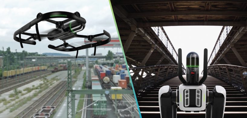
The Leica BLK ARC, an autonomous laser scanning module for autonomous mobile robots, brings its innovative 3D reality capture technology to robotic carriers and platforms. The first BLK ARC robotic integration is with the Boston Dynamics SPOT robot, with future integration plans for other robotic carriers.
This innovative technology expands opportunities to capture 3D data without human intervention, continuously scanning and storing real-time data while augmenting and improving the robot’s autonomous navigation system. The latest in Leica Geosystems’ solutions is especially useful in dangerous or hazardous environments, with automated and repeatable scan paths to command the robot carrier while keeping employees safe. BLK ARC completes both static and mobile scans during the same mission for greater scanning agility, which boosts productivity and eliminates extra work. BLK ARC can be used in a variety of use cases, such as documenting ongoing site conditions, exploring underground mines and for public safety applications such as fire or crime scene investigations and search and rescue missions.
The Leica BLK2FLY takes reality capture innovation to a new level as the world’s first autonomous flying laser scanner. BLK2FLY offers advanced obstacle avoidance while allowing users to plan entirely autonomous missions, from autonomous flight paths and scanning to intelligent return to home for battery changes to continue its mission.
Featuring simple operation and the fastest in-field setup time in the industry, Leica Geosystems’ latest UAV technology can scan buildings, inaccessible areas like rooftops and facades, and other complex structures with no scan shadows and safe, stress-free user operation. Additionally, the easy-to-use BLK2FLY Live App offers real-time video view, simple touch controls for automated scanning and virtual joysticks for manual flight. BLK2FLY is the perfect drone for documenting construction progress, rapid laser scanning for BIM processes and creating digital twins for retrofits and redesigns.
Click here to learn more about new Leica BLK autonomous technology, which delivers a complete reality capture workflow from automated scan planning to immediate data cloud processing and storage with easy, simple operation that democratizes autonomous reality capture worldwide.


