BK: Welcome to HxGN Radio. My name is Brian. Thanks for joining us today. We have the Leica BLK360. The world’s first imaging laser scanner was announced in the fall of 2016 and delivered to the first customers in the spring of 2017. After one year, this podcast explores how the technology has been used thus far, and where it’s going. We have Hugh Baertlein from Leica Geosystems and Scott Cohen with ABG Tag and Traq Inc. to discuss the Leica BLK360. Thanks for joining us today, gentlemen.
HB: Pleasure to be here.
SC: Thank you.
BK: Hugh, let’s start with you a little bit, let’s talk a little bit more about the innovative technology, the BLK360. Tell us all about it.
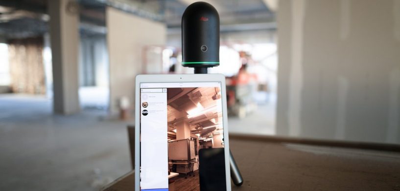
HB: Thanks, happy to. The BLK360, as you mentioned, was the world’s first imaging laser scanner. Show – we showed it at Autodesk University for the first time. It’s super compact, it’s not much larger than a soft drink can, compared to something that might be the size of a sewing machine, if anybody remembers what that it is. A sewing machine and, you know, it uses a car battery or something to run. So, it’s super compact, like I said, it weighs about two pounds. It’s unique in that it has one button and a multicolored light band. No display or anything. It captures – for those – the more technical or geeky people in the audience, it captures a full-dome laser scan, 360 degree HDR imagery, and an infrared panorama in about three minutes. Connects to a customer’s workflow via the Leica BLK360 app or Autodesk ReCap Pro for mobile.
We started shipping, as you mentioned, about a year ago. And it’s been really well received in the market, a lot of crazy stories about what people are doing with it. Aside from the technical specs, the industrial design is what really captures people’s attention.
BK: Good. Yeah, they brought one on the show last year when we did this, and it had been released recently, and we got to see it in person, and wow! I mean, just amazing how small it is and how efficient. Any – any specific customer, you know, use that stands out, that you just went, “Wow that’s – this is great!”?
HB: Every day it’s something new. I just learned what – what Scott’s going to be doing, you know, some of the stuff he does. It’s crazy, but just last week we had somebody fly to Machu Picchu to scan the walls and a lot of the pathways of the city, doing – doing research for an archaeological group out of Boston. So, every day something new.
BK: Something new, that’s great. Well yes, Scott, obviously you’re doing something with it, but you’re also doing it more in a traditional surveying sense, so tell us about how you’re using it and how it’s how it’s going so far.
SC: So we’re a subsidiary of American Biomedical Group that provides custom engineering internally and to third parties. The product will use the BLK360 with its – our AllTraq real-time location and tracking system. AllTraq’s location and IoT-similar sensors have found missions in healthcare, supply chain logistics, real estate, transportation, etc. The government and military are big customers of ours. You might recognise certain government agencies like the FDA and NASA and the Department of Defense. And we actually do quite a few missions with NASA. It’s pretty interesting, and if I could tell you about it, which I’ll be able to do like in 20 years when my NDAs are up [Laughs] –
BK: Of course! [Laughs]
SC: – you’d be like, “Hey, that’s really cool.”
BK: Yeah, yeah.
SC: But primarily, we’re using the Leica products to provide the real-time indoor measurements for our planning and implementation.
BK: Excellent. Okay, so you can’t say what’s being used for – for the NDA, and I understand that, but have you heard how they’re enjoying it, and how it’s changed, you know, their results, and also changing how the way you work as well?
SC: Yes, the employees … when we drop the data to them in the JetStream Viewer … and that’s really awesome to do because it all fits onto a USB stick. We take it from our workstation, pass it on out to them, they plug it into their computer, and then all of a sudden, all the work that we’ve been doing in front of them with the BLK360 becomes ready and usable, so they can look at the images, they get preservation of the work that we’re doing in the location that we’re doing it, and then they’re able to do all the measurements. And so for these types of customers, where they don’t have everyday exposure to Leica products, it’s mind-blowing to them.
BK: So what was the prior process for – say, for example, like you were just talking about, this really quick plug. What were they doing before that?
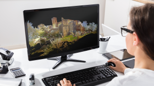
SC: Well, I mean, the way we used to do it is we would use handheld laser units, similar to the Distos, and we would point and click, and try and build out, in-building or, you know, site-specific measurements, and there’d be no additional information, so we’d go to a site that might have a couple of hundred of our transceivers in it, and we might leave the site with only, you know, five or six hundred data points or measurements. Now we can go in, set the BLK up, two, three minutes later, we’ve got millions and millions of points of data, we’ve got, depending upon the type of photos we do, either have a lo-res or a hi-res scan. We are starting to use some of the FLIR stuff, the infrared stuff, to help them identify leaks and the locations that they’re at. And it’s just an amazing product, because, you know – also, it’s a force multiplier for us, because I can go on there with one person and do the work of, like, three or four people. Oh yeah, it is –
BK: That’s great.
SC: You know, dollar for dollar, it’s a great tool.
BK: That’s right. Well Hugh, any insights on what we can expect in the future for the BLK360?
HB: Well, you know, right now we’re really focused on a couple of major areas. One is to continue the integration of the BLK360 into other workflows and other customer groups. The BLK360 was all about the democratisation of reality capture, so making it, like Scott explained, the step from the way he used to work to now, where he can capture millions of points in some minutes. We’re working on bringing that to more people and to making it more available. So, that’s one big focus. And it – and a recent example of that is with a cooperation we just signed with Matterport. Matterport does visualisation for commercial residential real estate and other segments, but they’ve been limited to indoor spaces, and by integrating the BLK with their imaging pipeline, they can now use their visualisation on the exteriors of buildings, which is super important especially in real estate, right? You want to buy a house, you want to see it. You might be looking at it from your – from your – in your den, but you want to see the outside of the house as well as the inside. So that’s one big – one big step and one major push that we have is getting into new segments with new partners.
And the second part isn’t sexy, and that is expanding our online support and user forum … having a place – creating a place where BLK users can come together, share their experiences, talk about any problems they’re having, and a place where our support people can take a temperature of the mood in the room, see how people are working, if they have problems, maybe getting some new ideas for new product features. More than that I really can’t talk right. I don’t have an NDA, but I know better than to promise what’s coming in the future. [Laughs]
BK: Sure, sure.
HB: Because things always change –
BK: Of course, of course.
HB: But we’re working on a lot. But I can guarantee you the BLK360 will remain in the Leica Geosystems focus.
BK: Excellent, excellent. Well, great things coming up, and you know, like you said, the second one maybe not quite as sexy, but at the same time very, very important. And, you know, people want that. They want to be involved, and they want to be a part of the growth of it, and they want to be able to give their feedback, so equally as important and exciting. So, thank you for sharing those things. Scott, how do you see this technology taking your industry and the future?
SC: As quality inputs are necessary for marketable solutions and location-based services, that point cloud information that the system generates for us is becoming transformative for deployments. We expect that there’s going to be a strong demand for what we’re calling datafied time-space studies, such as we’re conducting with NASA and manufacturing plants and other types of evidence-based architecture. Long term, I’m guessing that we’ll probably get the BLKs onto our drone systems. We manufacture a backpackable electric drone that has a 90-minute loiter time and a 23-pound payload. So, after what I’ve seen here this week, I can’t wait to get the BLK hanging from the bottom of that –
BK: Absolutely.
SC: – and using it. We do a lot of stuff in construction, ag, and Department of Defense stuff.
BK: Good. Exciting! It’s so great to hear how these things are really changing industries in such a dramatic way. So, thank you for sharing all of that. Thanks for the information, and glad to hear things are going forward.
For more information on this please go over to leica-geosystems.com. You can also visit AllTraq, that’s alltraq.com. And gentlemen, thank you for being here and taking the time and sharing all of this great stuff today.
SC: Thank you.
HB: Thanks so much for the invite.
BK: Go to hxgnspotlight.com for more episodes. Thanks so much for joining us. Have a wonderful day.


